15 Munt la Schera


Season
June, July, August, September, OctoberContact
NationalparkzentrumUrtatsch 2
7530 Zernez
Tel. +41 (0)81 851 41 41
Mobile -
www.nationalparkzentrum.ch
Schweizerischer Nationalpark -
It leads through steppe landscape, quite untypical in Switzerland, with wonderful views towards the Parco Nazionale dello Stelvio (I) in the south-east. Interesting geological phenomena can also be observed.
Particularities
Former mines at Buffalora, creeping soils on Munt Chavagl, view from Munt la Schera.
For this hike the Focus leaflets Der geologische Kreislauf and Die Schmetterlinge am Munt la Schera (only available in German) can be purchased at the National Park Centre in Zernez.
Geological nature trail in the opposite direction on this route (start at Il Fuorn/P6).
Route-information
Route-information
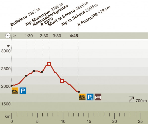
- Length
- 13.00 km
- Vertical heigth
- 700 m
- Time required
- 4 hours 45 minutes
- Level technique
- Easy
- Level condition
- Middle
Details
Difficulty: white-red-white / medium
The ascent to Munt la Schera can be left out. Apart from a few steep places, the ascent is relatively easy.
Arrival
Starting and end point can be reached by post bus (bus stops: Buffalora/P10 und Il Fuorn/P6).
Infrastructure
Il Fuorn: www.ilfuorn.ch
- Playground
- Picnicplace
Arrival
- Starting point
- Buffalora (Altitude: 1967 m)
- Arrival by public transport
- Buffalora P10 Timetable SBB
- Destination
- Il Fuorn (Altitude: 1794 m)
- Arrival by public transport
- Il Fuorn P6 Timetable SBB
Suitable for
The offer is suitable for
- Adults
- Children from 7-12 years
- Children >12 years
- 50+
- Families
- Groups