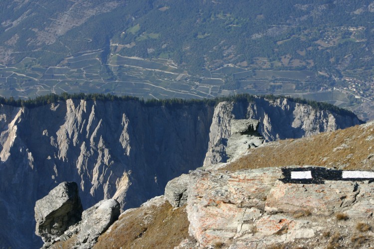
Grand Canyon? Illgraben!


Season
All season
Naturpark Pfyn-Finges - Alps, flowers, mountain lakes and a unique view into the Valais Grand Canyon
In order to appreciate the true size of the Illgraben, climb up metre by metre from Oberems over different stages of vegetation until you are above the tree line and at the upper Meretschi Alp and its lakes. At the time of the Ice Age, this was the approximate thickness of the glacier. A desolate landscape and colourful flower meadows take you over alpine paths past lakes, rock glaciers and scree. The ascent up to Illhorn from the Pas d l'Illsee is worthwhile, because your muscular effort will be rewarded with the view into the Valais Grand Canyon. From the Pas d l'Illsee we recommend the more pleasant detour in the direction of Ponchet, which will again bring you to the edge of the "crater" and shows the Illgraben from another perspective. The way back takes the alpine road through an open larch and pine wood.
Route-information
Route-information
- Length
- 17.00 km
- Vertical heigth
- 650 m
- Altitude difference ascent
- 1600 m
- Altitude difference descent
- 950 m
- Time required
- > 6h
- Level technique
- Middle
- Level condition
- Hard
Details
Travel by train, (bus), cable car:
Arrival in Turtmann railway station - then with the bus or on foot to the valley station of the LTUO - cable car to Oberems summit station - follow the hiking trail
Travelling by car:
Take the cable car from Turtmann valley station to Oberems summit station - follow the hiking trail
Oberems – Untere Meretschialp (Lower Meretschi Alp) (1h40) – Obere Illalp (Upper Ill Alp) (3h40) – Illhorn (4h30)
Option for families
From Chandolin an alpine road in the direction on Ponchette leads to the Illgraben in approx. 50 minutes. If the little feet are not too tired, it is worthwhile to descend to the Alp Ponchet, where there are mighty larch trees and gentle alpine meadows. 2 hours must be calculated for the return walk with children.
Infrastructure
Parking area at Turtmann valley station and in the near vicinity
Arrival
- Starting point
- Oberems (Altitude: 1333 m)
- Arrival by public transport
- Oberems, Seilbahn Timetable SBB
- Destination
- Chandolin (Altitude: 1978 m)
- Arrival by public transport
- Chandolin, poste Timetable SBB
Suitable for
The offer is suitable for
- Adults
- 50+
- Groups