Navigating the Swiss Parks Website
Map
i

Mont Soleil Tour

E-bike itinerary
Time required: 2 - 4hLength: 42.00 km

Contact

Parc du Doubs
- -
Place du 23-Juin 6, CP 316
2350 Saignelégier
Tel. +41 (0)32 420 46 70

www.parcdoubs.ch

Parc du Doubs - This wonderful tour will calmly lead you from Saignelégier towards the Mont-Soleil and back to the start. You will come across beautiful landscapes within the Doubs and Chasseral Nature Parks.

Route-information

Route-information

Length
42.00 km
Amount untarred route
2.00 km
Altitude difference ascent
500 m
Altitude difference descent
500 m
Time required
2 - 4h
Level technique
Easy
Level condition
Middle
Height profile view map

Details

Curiosities along the way:
1. Etang de la Gruère
2. Hamlet Les Cerlatez
3. Mont Soleil and Mont Crosin
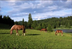
4. Pastured woodlands
Equipment / Equipment rent

Rent a Bike - bike rental station
Les Chemins de fer du Jura
Rue de la Gare 11
2350 Saignelégier
http://www.les-cj.ch ou www.rentabike.ch
+41 (0) 32 952 42 75
Opening hours
Mo - Fr: 5:15 a.m.- 9:30 p.m.
Sa: 6:00 a.m.- 9:30 p.m.
Su: 7:00 a.m.- 9:30 p.m.

Signalization

Signage: From Saignelégier, follow the signs "Nr. 7" until you reach the Mont-Soleil. Then follow the signs "Nr. 54" until Tramelan and the local signs until the Etang de la Gruère. Finally, follown the signs "Nr. 7" until you arrive back in Saignelégier.

Safety advices

From 16 years old onwards

Possibilities for catering

Saignelégier
Les Cerlatez
Les Reussilles
Mont Crosin
Mont Soleil

Infrastructure

  • Playground
  • Picnicplace
  • Toilet

Arrival

Starting point
Saignelégier (Altitude: 981 m)
Arrival by public transport
Saignelégier (gare) Timetable SBB
Destination
Saignelégier (Altitude: 981 m)
Arrival by public transport
Saignelégier (gare) Timetable SBB

Suitable for

The offer is suitable for

  • Adults
  • 50+
  • Groups

The offer has been particularly developed for

  • Upper Secondary School Classes
  • Association/Companies

Discovering underway

Parc du Doubs

Franches-Montagnes plateau

The Franches-Montagnes plateau lies at 1000 m with its pastured woodlands, groups of trees and pine forests is the major attraction of the region. The region is rich in natural, cultural and culinary points of interest.

Natural landscape / HabitatCultural landscape
Parc du Doubs

Etang de la Gruère

The walk round the Etang de la Gruère is easily accessible for young and old. A beautifully laid-out trail (wood shavings and board walks) reveals new and wonderful views at every step around this fantastic moorland lake.

Natural monumentNatural landscape / Habitat
Parc du Doubs

Les Cerlatez Nature Centre

Close to the nature reserve « l’Etang de la Gruère », Les Cerlatez Nature Centre has the objective to raise awareness on environmental issues. Located in the heart of the Franches-Montagnes, it offers an array of guided tours, exhibitions and hikes.

Visitor centerInformation center

Map