Navigating the Swiss Parks Website
i

Graubünden Route

Bicycle tour
Length: 30.00 km

Season

All season

Contact

Bergün Filisur Tourismus
Veja Stazion 11
7482 Bergün
Tel. +41 81 407 11 52

www.berguen-filisur.ch/

Parc Ela - Rugged and steep up through the Schinschlucht (gorge) to Tiefencastel, later nice and easy through the Alvaneuer Albulatal, where sulphur springs promise relief. High above, red trains on the curved Landwasser viaduct.

The wide and steep Schinschlucht leads to Tiefencastel and thus into the Ela Park, the largest nature park in Switzerland. Here water flows in all directions, dinosaurs have left their traces in the rocks and three languages are spoken.

Route-information

Route-information

Length
30.00 km
Altitude difference ascent
950 m
Altitude difference descent
260 m
Level technique
Hard
Level condition
Hard
Height profile view map

Details

Beware: busy main road Thusis-Tiefencastel (dangerous tunnels in Schinschlucht gorge, switch on bike lights), please note rail recommendation No. 50

Arrival

Starting point
Thusis (Altitude: 672 m)
Arrival by public transport
Thusis Timetable SBB
Destination
Bergün/Bravuogn (Altitude: 1367 m)
Arrival by public transport
Bergün/Bravuogn Timetable SBB

Suitable for

The offer is suitable for

  • Adults

Discovering underway

Parc Ela

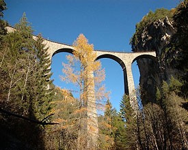
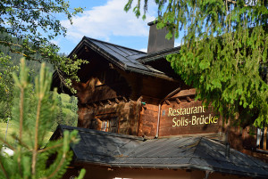
Restaurant Solisbrücke

The family-friendly restaurant is directly adjacent to the Solis Bridge, affording a view of an impressive landscape. The Salzgeber family will welcome you with homemade specialties by the cocklestove in the winter, and in the summer on the terrace.

Restaurant

Routes in the vicinity

Naturpark Beverin

Walserweg Graubünden Etappe 7

Ein Transitweg führte einst vom Albulatal über Samest ins romanische Schams. Wir folgen seinen Spuren und geniessen die Sicht hinüber zum Schamserberg überragt vom Piz Beverin.

Hiking trail
Time required: 4 hoursLength: 15.00km

Map