Walk Leuk - Agarn


Season
All season
Links
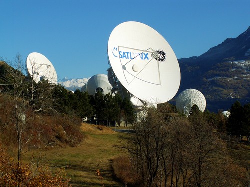
Naturpark Pfyn-Finges - This walk starts at the satellite ground station, goes over traditionally cultivated fields in Brentjong to the rocky steppes. Having arrived in the Rhone valley, we recommend walking through Leukerfeld, which is outstanding for bird-watching.
The walk starts at the Leuk - Guttet junction bus stop. Follow the trail to the satellite ground station, which you can see from afar. After passing through the traditionally cultivated fields in Brentjong, you will soon enter the rocky steppes. At the high bridge a short break is worthwhile, so that you can look out for the wallcreeper in the gorge.
The route continues down into the valley to the River Rhone and along the river bank in a westerly direction until you reach the bridge that brings will bring you to Leukerfeld. There are specially constructed hides available for bird-watching, so that the animals can be observed undisturbed in their natural habitat.
We cross the cantonal road and finally arrive in Agarn. In particular, the old village centre with the Green Room and the former Doktorgut should be visited before you return to the Agarn village bus stop for the bus that will take you back to the railway station.
Route-information
Route-information
- Length
- 11.00 km
- Altitude difference ascent
- 300 m
- Altitude difference descent
- 600 m
- Time required
- 4 - 6h
- Level technique
- Middle
- Level condition
- Middle
Arrival
- Starting point
- Leuk Satellitenbodenstation (Altitude: 892 m)
- Arrival by public transport
- Leuk, Abzw. Guttet Timetable SBB
- Destination
- Agarn (Altitude: 621 m)
- Arrival by public transport
- Agarn, Dorf Timetable SBB
Suitable for
The offer is suitable for
- Adults
- Children from 7-12 years
- Children >12 years
- 50+