Flühli - Chessiloch Waterfall

Season
April, Mai, June, July, August, September, OctoberContact
UNESCO Biosphäre EntlebuchBiosphärenzentrum UNESCO Biosphäre Entlebuch
Chlosterbüel 28
6170 Schüpfheim
Tel. +41 41 485 42 50
www.biosphaere.ch
UNESCO Biosphäre Entlebuch - Entertaining walk to the waterfall at the Chessiloch suspension bridge
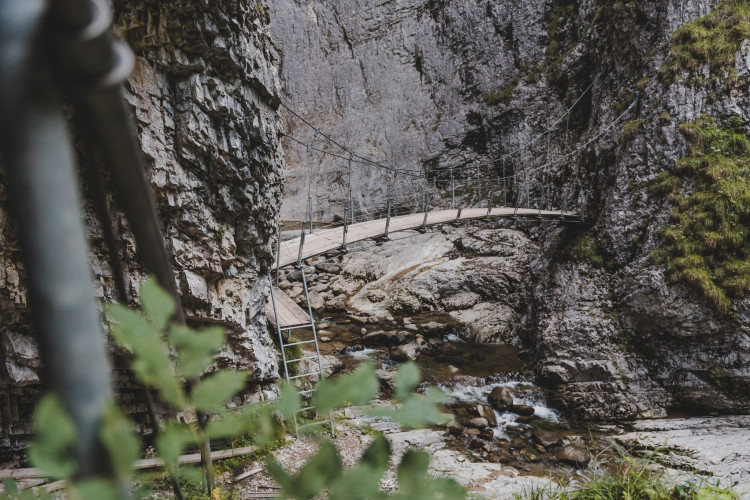
A waterfall in the mysterious realm of sulphur
Today we finally want to see the oft-mentioned Chessiloch waterfall, plus a sulphur spring and an amazing suspension bridge. At the former Kragen glassworks, we dive into the green forest on a pleasantly wide gravel path. The birds are trying to outdo each other with their singing, accompanied by the watery notes of the Seebenbach on the right – isn't nature wonderful! After five minutes, a narrow inconspicuous path branches off to the right, down towards the stream; it's marked with a sign on the left saying "Schwefelquelle" (sulphur spring). The path down to the spring is short but rather steep; it has a handrail. No holding back, now: everyone has to take a gulp of the healthy, sulphurous water, which used to be considered curative. Pinch your nose if necessary.
Picnic spots and viewing platforms
We head back to the gravel path and continue on our way to reach the first viewing platform overlooking a breathtaking water landscape formed by the Rotbach over the centuries. A paradise both for geologists and the eye of the layman. Rampion, campanula, wood cranesbill and other colourful wildflowers line our way and we soon meet a well-appointed barbecue and picnic spot in a clearing. Looking down through the forest reveals another barbecue spot beside the river. There's even a very special toilet here for visitors. Various footpaths can be taken from here, but we're heading for Chessiloch, which is 10 minu
Route-information
Route-information
- Length
- 8.59 km
- Altitude difference ascent
- 259 m
- Altitude difference descent
- 259 m
- Time required
- 2 hours 35 minutes
- Level technique
- Easy
- Level condition
- Middle
Details
Sörenberg Flühli Tourismus
Rothornstrasse 21
CH-6174 Sörenberg
Telefon +41 (0)41 488 11 85
www.soerenberg.ch
Equipment / Equipment rent
Sturdy footwear and something against the rain.Signalization
Dorf, Flühli - Schlund - Kneippanlage Schwandalpweiher - Schwandalp - Chrageberg - Kragen - Chessiloch - Kragen - Hüttlenen - Dorf, Flühli
Safety advices
Informationen zum aktuellen Zustand des Wanderwegnetzes von Sörenberg-Flühli erhalten Sie täglich auf der Panoramawanderkarte.
Infrastructure
- Fireplace
Arrival
- Starting point
- Flühli
- Destination
- Chessiloch
Suitable for
The offer is suitable for
- Adults
- Children < 6 years
- Children from 7-12 years
- Children >12 years
- 50+
- Families
- Groups