


UNESCO Biosphäre Entlebuch
Luftseilbahn Brienzer Rothorn
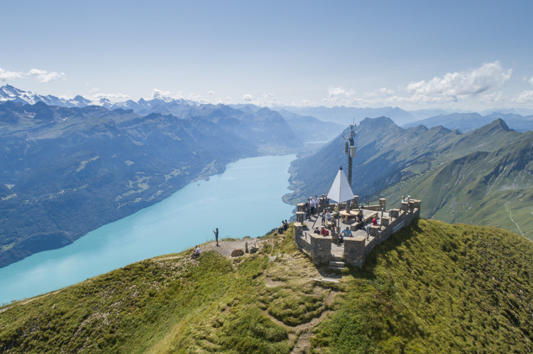
Auf das Brienzer Rothorn, den höchsten Punkt des Kantons Luzern, gelangen Sie bequem in weniger als 10 Minuten mit der Luftseilbahn.
Infrastructure SummerInfrastructure WinterFunicular
UNESCO Biosphäre Entlebuch - The first leg of the Emmenuferweg is a place of wonder. The start on Brienzer Rothorn mountain is simply spectacular. Accompanied by amazing views of Lake Brienz and the Bernese Alps, the route leads to the source of the Emme river and enters the UNESCO Biosphere Entlebuch.
The tour begins with incredible views from the highest peak of the Canton Lucerne, the Brienzer Rothorn. Make sure you stop for a while when you get to the top to look at the breathtaking panorama. To the north, the views range across the area of the Waldemmental. When the weather is clear, you can also see Napf mountain, the lake region behind it and all the way to the Black Forest. On the other side, sparkling Lake Brienz and the snow-covered Eiger, Monch and Jungfrau mountains are visible, as well as up to 690 other peaks.
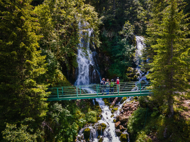
Past the lookout, the descent begins in the direction of the Eisee. The small mountain lake is situated at the foot of Arnihaaggen mountain, nestled in a mosaic of scree slopes and green meadows. The lakeshore is a perfect place to take a short break. Cool your feet in the icy mountain lake, if you don’t mind the cold, before you start descending in the direction of the Emmensprung. The path zigzags downhill until you reach the headwater at an altitude of 1465 m. As if out of nowhere, the spring burbles out of the ground and seeks a path down to the valley, where it eventually merges with the Waldemme. After a few steps you come across two waterfalls in the midst of a small forest, where the water plunges down over moss-covered rocks.
Across peaceful meadows the route follows the forked streams down to the valley. Along the way you enter the UNESCO Biosphere Entlebuch with its incomparable river and moor landscapes, lovely riverside forests and
UNESCO Biosphäre Entlebuch
c/o Biosphärenzentrum
Chlosterbüel 28
CH-6170 Schüpfheim
Telefon +41 (0)41 485 42 50
www.biosphaere.ch
Gutes Schuhwerk, Regenjacke & genügend Trinkwasser für unterwegs gehören zu jeder Wanderung.
Weitere Tipps zum sicheren Wandern, Informationen zu Mutterkuhherden und Herdenschutzhunden und vieles mehr gibt es auf der Webseite der Schweizer Wanderwege.
Brienzer Rothorn - Eisee - Emmensprung - Sörenberg (Dorf)
Die gesamte Wegstrecke ist mit den Wegweisern «83 Emmenuferweg» ausgeschildert.