Moorlandschaftspfad Etappe 1: Habkern / Sörenberg


Season
Mai, June, July, August, September, OctoberContact
UNESCO Biosphäre EntlebuchBiosphärenzentrum UNESCO Biosphäre Entlebuch
Chlosterbüel 28
6170 Schüpfheim
Tel. +41 41 485 42 50
www.biosphaere.ch
UNESCO Biosphäre Entlebuch -
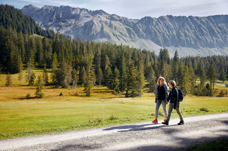
Die erste Etappe des Moorlandschaftpfades überrascht mit scharfen Kontakst zwischen dem kantigem Schrattenfels und dem weichem Moorboden.
Sharp contrast between the sharp rock of the schrattenfluh and the soft ground of the moor land! The moor landscape is characterized through the extreme contrast between smooth, round forms of the surface of the moor land and the sharp relief of the Schratten-fluh. Big parts of that area are very wild and of nearly intact beauty. On the "Chnubeln" and "Eggen" in the typical location of the moor land, there are traditional alps with deep hang-ing shingle roofs.
Comfortably, you walk on traffic free brash streets through the alpine and Nordic ski area of Soerenberg. The variety of the types of moor land is imposing.
Specials in the moor of the Hilferenpass
S: The moraines by Pfosteregg and Sitenegg count as witnesses of the last ice-age.
T: The hunting ground Tannhorn (ca. 12 km2, 1944 established) presents loads of cham-ois and venison.
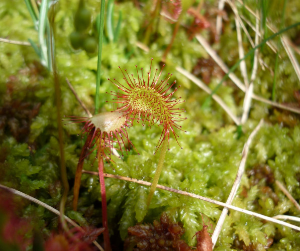
U: The fantastic area of Laubersmadghack and Türnliwald is because of the pine bog and the little water areas worth seeing. In the light forests live rare species of animals.
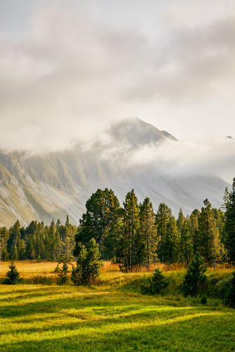
V. The Schrattenfluh attracts attention with typical forms of karst like sinkholes and branched cave systems. In the opposite of the wet moor land, on the bare karst does not exist ground level water because it seeps away belowground through clefts and gaps.
Note(s)
The route is marked with the pointer «Moorlandschaftspfad» and can also be made in the opposite direction.
The starting point Kemme
Route-information
Route-information
- Length
- 16.76 km
- Altitude difference ascent
- 640 m
- Altitude difference descent
- 816 m
- Time required
- 5 hours 30 minutes
- Level technique
- Easy
- Level condition
- Middle
Details
UNESCO Biosphäre Entlebuch
c/o Biosphärenzentrum
Chlosterbüel 28
CH-6170 Schüpfheim
Telefon +41 (0)41 485 42 50
www.biosphaere.ch
Möchten Sie das Moor mit einem Experten erkunden? Gerne organsiert die UNESCO Biosphäre Entlebuch geführte Rundgänge bzw. Exkursionen. Informieren Sie sich beim Biosphärenzentrum: zentrum@biosphaere.ch oder Tel. +41 (0)41 485 42 50.
Equipment / Equipment rent
Gutes Schuhwerk und eine allwettertaugliche Ausrüstung sind unerlässlich. Empfehlenswert sind Fernglas, Pflanzen- und Tierbestimmungsbücher, evtl. auch ein Frottetuch, mit dem nach dem Barfusswandern die Füsse getrocknet werden können.
Signalization
- Sörenberg, Post - Abzweigung Rossweid - Salwide - Blatte - Unt. Laubersmad - Arnibergegg - Spierweid - Hinderes Hübili - Kemmeribodenbad
- Die Route ist mit dem Signet «Moorlandschaftspfad» markiert und kann auch in umgekehrter Richtung begangen werden.
- An diese Strecke können die Etappen «Hilferepass» oder «Glaubenberg» angeknüpft werden.
Variante
Gondelbahn Sörenberg- Rossweid: Zeiterspranis 30 Minuten
Informationen zur Gondelbahn finden Sie unter: Bergbahnen Sörenberg
Safety advices
Handy Empfang ist teilweise schwierig bis unmöglich.
Price information
Bookable as a package deal: While you hike along the signposted moorland trail, enjoy the fascinating natural landscapes and enjoy the lunch provided at the most beautiful spots, your luggage travels to the next overnight accommodation. Here, too, you can enjoy a variety of options - from an overnight stay in a tipi on an alpine pasture to a 3-star hotel with a regional 4-course menu - and fall into a deep, restful sleep.Arrival
- Starting point
- Sörenberg, Postautohaltestelle Sörenberg, Post
- Arrival by public transport
- Sörenberg, Post Timetable SBB
- Destination
- Kemmeribodenbad, Postautohaltestelle Kemmeriboden
- Arrival by public transport
- Kemmeriboden Timetable SBB
Suitable for
The offer is suitable for
- Adults
- 50+