Niesen-Diemtigtal panoramic hiking trail
Season
June, July, August, September, OctoberLinks
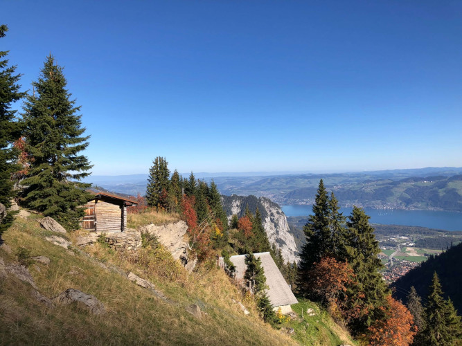
Naturpark Diemtigtal - Hiking from the Niesen into the Diemtigtal, you have a magnificent view of Lake Thun and the Simmen and Diemtigtal valleys.
The 3.5 km long route up Niesen Kulm is divided into two sections. The 26-minute ride with the two funiculars up "the swiss pyramid" provides an impressive panorama of Lake Thun and the Kander valley. Once you reach the top station, a wonderful panoramic view of the neighbouring valleys and the peaks of the Bernese Oberland awaits you. The signposted mountain trail to the neighbouring Diemtigtal leads over alpine meadows, through forests and stone fields to the village of Oey.
Route-information
Route-information
- Length
- 12.29 km
- Altitude difference ascent
- 79 m
- Altitude difference descent
- 1749 m
- Time required
- 4 hours 30 minutes
- Level technique
- Easy
- Level condition
- Middle
Details
A hiking map is available from the Diemtigtal Nature Park office.
Diemtigtal Nature Park
Bahnhofstrasse 20
3753 Oey
Phone 033 552 26 00
info@diemtigtal.ch
www.diemtigtal.ch
Open or closed?
Find out in our > summer sports report
Equipment / Equipment rent
Mountain boots, weather appropriate clothing (sun/rain protection), hiking poles, food and sufficient drinks for the waySignalization
The mountain trail is marked with yellow directional signs and green route fields and leads from the Niesen mountain station down to the Oberen and Unteren Stalde, over the Chummli to the Geeri. This is where the trail splits:If your destination is Oey railway station, turn right and follow the path via Bruchgeere via Zünegg to Hasli, where you tackle the last descent to the railway station.
Alternatively, you can continue straight on at Geeri until you reach the Hoschüpfe viewing platform. Here you get a last view over Lake Thun before you reach the Springenboden area via Untere Drunen. The hiking trail leads you from here down to the valley road in Horboden, where you can either hike along the valley hiking trail to Oey or return by PostBus from Horboden, Chirel.
By the way: If you book an overnight flat rate at the Gsässweid Inn from the Diemtigtal Nature Park office, you will spend the night in a dormitory or double room and be taken back to the Oey-Diemtigen or Mülenen railway station the next day after breakfast.
Safety advices
Despite the proverb «if the Niesen has a hat, the weather will be fine again», it is important to pay attention to the weather situation. Around the peaks of the Niesen chain, snow can sometimes lie until May/June.The Panorama Trail leads through pastures with cattle and along fenced flocks of sheep, which are guarded by dogs. It is recommended that you do not bring a dog on the hike. Please note the corresponding information boards on site.
Arrival
- Starting point
- Bergstation Niesen Kulm (Mülenen)
- Arrival by public transport
- Niesen Kulm Timetable SBB
- Destination
- Bahnhof Oey-Diemtigen
- Arrival by public transport
- Oey-Diemtigen, Bahnhof Timetable SBB
Suitable for
The offer is suitable for
- Adults