


Chemin de La Dôle
Parc naturel régional Jura vaudois - This hike takes you through lovely meadows and forests up to the Jura’s Dôle Mountain and over to La Givrine.At the summit with a 360° panorama, you will have a breathtaking view of Lake Geneva, Mont Blanc in France and the Jura crest and plateau.
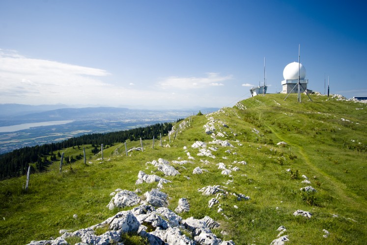
This superb 14 km loop hike will take you across verdant pastures and Jura forests to La Dôle, whose white radar balls are discernible from afar. The route starts at St-Cergue overlooking Lake Geneva. At this point already, stunning panoramic views of the Alps and Mont-Blanc await visitors. You can also enjoy the scenery a bit higher up, at the former castle. It was destroyed during the Burgundian Wars, and only the site where it stood remains today. After only half an hour's walk you will find yourself in a typical Jura landscape and be surrounded by peace and quiet.
The hilltop of La Barillette (1,528 metres), just to the east of La Dôle, marks the end of the first climb. The forest reaches up to the summit here. The vegetation changes a little higher up, becoming alpine and surrounding the Dôle cirque. Crowfoot and gentians cover the fields as far as the eye reaches. Once you have reached the peak, you will be astounded by the breathtaking panorama unfolding before you. Lake Geneva with Geneva and its fountain at the western tip, and Mont-Blanc in the south, forming the horizon line. J.-W. Goethe came here on 26 October 1779 on his way to Geneva. He is quoted as saying: "There are no words to describe the grandeur and the beauty of this spectacle.” You will surely agree!
If you're lucky, you might even spot a few chamois, which live on the slopes around the summit. Meanwhile, technology buffs can admire the large, white radar balls which are discernible from afar. The ob
Route-information
Route-information
- Length
- 16.00 km
- Vertical heigth
- 1620 m
- Altitude difference ascent
- 900 m
- Altitude difference descent
- 720 m
- Time required
- 5 hours
- Level technique
- Easy
- Level condition
- Hard
Details
Signalization
SwitzerlandMobility 116Arrival
Arrival
- Starting point
- Saint-Cergue (Altitude: 1041 m)
- Arrival by public transport
- St-Cergue Timetable SBB
- Destination
- La Givrine (Altitude: 1228 m)
Suitable for
The offer is suitable for
- Adults
- Children from 7-12 years
- Children >12 years
- 50+
- Families
- Groups

Season
Mai, June, July, August, September, October, NovemberContact
Office du Tourisme de Saint-CerguePlace Sy-Vieuxville 3
1264 Saint-Cergue
Tel. +41 22 360 13 14
Fax +41 22 360 24 74
www.lacote-tourisme.ch