Navigating the Swiss parks network
Discover all offers

Swiss Parks Network
Monbijoustrasse 61
CH-3007 Berne

Tel. +41 (0)31 381 10 71
Mob. +41 (0)76 525 49 44
info@parks.swiss

Contact us

News from the parks

10th National Swiss Parks Market, 21 May 2026

On 21 May 2026, the Bundesplatz will transform into a festival of culinary delights. Taste the finest regional specialities from the Swiss parks and meet passionate producers! The programme includes tastings, games and activities for young and old, music – everything you need to enjoy for a great time. Save the date!

9th national Swiss parks market, 15th May 2025

Am Donnerstag, 15. Mai 2025, ist der Pärke-Markt zurück auf dem Bundesplatz in Bern. Auf dem Programm stehen Spezialitäten, Degustationen, Spiele und Mitmach-Aktivitäten an den Ständen, Musik und alles, was es braucht für eine gute Zeit. Reservieren Sie sich das Datum schon jetzt!
Show all

Bounavau – Charmey

Hiking trail
Time required: 6 hoursLength: 15.80 km

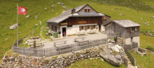
Parc naturel régional Gruyère Pays-d'Enhaut - This stage passes through the alpine pastures where Gruyère d'alpage PDO is made. From Tsermon, the magnificent view leads the eye to Lake Geneva. After a quiet descent into the Motélon valley, you reach Charmey via la Monse and then la Tzintre.

From Bounavau, head towards the Chalet de Tsermon. Walk down towards Le Motélon valley, first on the footpath, then on the road that runs along the Riau du Motélon. Continue for 2.5 kilometres. Just after you walk past the Chalet de La Générale, walk uphill towards La Vonderrveire. At point 1341, turn left and head towards the Gros Haut Crêt mountain farm. The hike to the Vanil de la Monse is very hilly. Walk through the Les Plans mountain farm, turn right and continue walking downhill until you reach the La Jogne river. Cross the river. The hamlet of La Tzintre is on the other side. Continue on until you reach the centre of Charmey village.

Route-information

Length
15.80 km
Altitude difference ascent
839 m
Altitude difference descent
1593 m
Time required
6 hours
Level technique
Middle
Level condition
Hard
Height profile view map

hiking shoes, picnic (and evening meal and overnight stay at Bounavau), weather-appropriate clothing (NB : mountain weather is very changeable)

Arrival

Starting point
Bounavau (Altitude: 1620 m)
Destination
Charmey (Altitude: 890 m)

The offer is suitable for

  • Adults
Parc naturel régional Gruyère Pays-d'Enhaut

L’Etoile Hotel-Restaurant

The hotel-restaurant L’Etoile in the village centre of Charmay is difficult to miss. The building originates from the 17th century and has been completely restored, rustic-style and tastefully at the same time. Taste the specialities from the Gruyère

RestaurantHotelCafé
Parc naturel régional Gruyère Pays-d'Enhaut

Cabane CAS de Bounavau

Nestling on the western slopes of the Vanil Noir, the Cabane de Bounavaux is at the heart of the nature reserve on Fribourg's highest peak. Guarded from late May to early October, it welcomes visitors every day during this period.

Alpine hut and shelter

Season

Mai, June, July, August, September, October

Contact

Parc naturel régional Gruyère Pays-d'Enhaut
Place du Village 6
1660 Château-d'Œx
Tel. +41 (0) 26 924 23 33

www.gruyerepaysdenhaut.ch

Map