Navigating the Swiss parks network
Discover all offers

Swiss Parks Network
Monbijoustrasse 61
CH-3007 Berne

Tel. +41 (0)31 381 10 71
Mob. +41 (0)76 525 49 44
info@parks.swiss

Contact us

News from the parks

10th National Swiss Parks Market, 21 May 2026

On 21 May 2026, the Bundesplatz will transform into a festival of culinary delights. Taste the finest regional specialities from the Swiss parks and meet passionate producers! The programme includes tastings, games and activities for young and old, music – everything you need to enjoy for a great time. Save the date!

9th national Swiss parks market, 15th May 2025

Am Donnerstag, 15. Mai 2025, ist der Pärke-Markt zurück auf dem Bundesplatz in Bern. Auf dem Programm stehen Spezialitäten, Degustationen, Spiele und Mitmach-Aktivitäten an den Ständen, Musik und alles, was es braucht für eine gute Zeit. Reservieren Sie sich das Datum schon jetzt!
Show all

Au fil du Doubs

Hiking trail
Time required: 20 hoursLength: 67.30 km

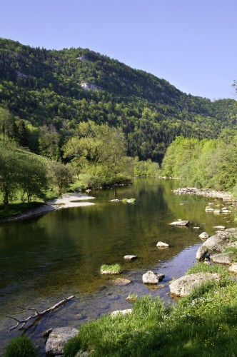
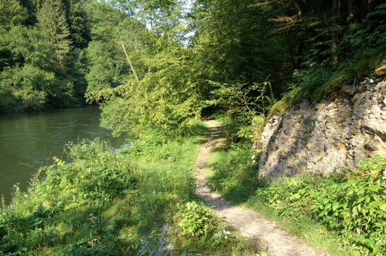
Parc du Doubs - This hike does full justice to its name. The trail leads from Les Brenets near La Chaux-de-Fonds to St. Ursanne, almost always alongside the River Doubs and crossing the Doubs Regional National Park from west to east.

What could be better than a four-day hike alongside the River Doubs, with time to tank up on energy, relax and enjoy the unspoiled natural world away from civilisation! And in some places even (not exactly by choice) do without phone calls, surfing and Twitter!

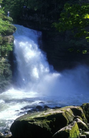
The trail follows the river, passing scenic and symbolic gems such as the Saut de Doubs, the Échelles de la Mort, La Goule, the French-Swiss border village of Goumois, Soubey and finally the medieval town of St. Ursanne. On the first two stages, the Doubs forms the border between France and Switzerland before it makes a 23km long loop in Swiss territory.

The many restaurants lining the route serve home-made trout specialities, sometimes blue, sometimes in a delicate herb sauce. Now and then a bridge, walkway or even a boat invite you to cross the river.

Route-information

Length
67.30 km
Amount untarred route
53.40 km
Vertical heigth
3182 m
Altitude difference ascent
1422 m
Altitude difference descent
1760 m
Time required
20 hours
Level technique
Easy
Level condition
Middle
Height profile view map

Possibility to catch a boat to go to the Saut-du-Doubs waterfall. Infos: www.nlb.ch

Possibilities for catering

Les Brenets:
- Restaurant Les Rives du Doubs: www.rives-du-doubs.ch
- Restaurant Bellevue: www.campingbrenets.ch /
Maison Monsieur:
- Hôtel restaurant Maison Monsieur: www.maisonmonsieur.ch
- Hôtel de la Rasse (FR): www.hoteldelarasse.fr /
Goumois:
- Auberge le Theusseret: letheusseret.blogspot.com
- Hôtel du Doubs : www.hoteldudoubs.ch
- Hôtel Taillard (FR): www.hotel-taillard.fr /
Soubey:
- Hôtel du Cerf: www.juragourmand.ch/hotelducerf.htm
- Domaine de Tariche: www.tariche.ch /
St-Ursanne:
- Maison du Tourisme : www.maisondutourisme.ch
- Hôtel Restaurant de la Couronne: www.hotelcouronne.ch
- Hôtel du Boeuf: www.hotelduboeuf.ch

Signalization

Route n° 95

Arrival

Starting point
Les Brenets (Altitude: 849 m)
Arrival by public transport
Les Brenets Timetable SBB
Destination
St-Ursanne (Altitude: 440 m)

The offer is suitable for

  • Adults
  • Children >12 years
  • 50+
  • Families
  • Groups

The offer has been particularly developed for

  • Third cycle (1st – 3rd grade, lower secondary)
  • Upper Secondary School Classes
  • Association/Companies
Parc du Doubs

Saut du Doubs

The largest waterfall along the Doubs The water plunges down 27 metres. In the beautiful gorge there are relaxing restaurant terraces for you to stay a while. Those who wish can make a boot trip on the Lac des Brenets.

Natural monumentNatural landscape / HabitatViewpoint

Season

All season

Contact

Parc naturel régional du Doubs
6 Place du 23 Juin, CP 316
2350 Saignelégier

www.parcdoubs.ch/

Map